Showing posts with label documentary. Show all posts

Wednesday, 17 October 2012

Corfu: A Tale Of Two Islands

   An ITV documentary following the lives of expats and tourists enjoying the attractions of the Greek island.    


Episode: 1/8

  Tucked away in this jolly film about the lives of expats on Corfu is an extraordinary snippet. It is, according to Mary (a Shirley Valentine who arrived in 1980 as a holiday rep and married taverna owner Nico) cheaper to order certain food online from a UK supermarket and pay someone to deliver it than buy it locally. Such is the state of the Greek economy, even olive oil is cheaper.  The rest of the documentary focuses on the work of wedding planner Sally, another rep who stayed, although she didn’t marry because of her fiance’s fiercely traditional attitude to women.


Episode: 2/8

Marcus sells and develops multimillion pound, beachfront properties. He’s profiting from Corfu’s shift in industry from the agriculture that dominated the economy up until the 60’s, to tourism today. But as the island grows more popular it is becoming increasingly difficult to track down the picture-perfect plot.
Marcus’s most recent client is Oxfordshire housewife Susie who, along with husband Mark, has scoured Corfu for the perfect retreat from the stresses of life in the UK.
Further inland in the shadow of the “The Almighty”, Mount Pantokrator, lies a village where one couple are trying to reinvigorate the old ways. Mark Hendriksen and his Dutch wife Saskia Bosch fell in love with the abandoned village of Old Perithia while on holiday. The pair have now started an ambitious project to breathe life back into the idyll, and the first step is to get theirBoutique B&B up and running.


Episode 3/8:

This episode focuses on Bernard and Heather, who are celebrating their 60th wedding anniversary during their annual holiday. Also featured are Tim and Victoria, who love Corfu so much they built their own house there, and a couple of pop stars looking to make it big.


Episode 4/8:

The series meets 17-year-old Abi who is finding it hard to get work over the summer season and an ex-antique dealer from Kensington attempting to live the artistic dream in Corfu. The show also meets Scarlett who came to Corfu on holiday and never went back home.


Episode 5/8:

A hotel manager feels the impact of the economic downturn and a group of tourists takes a trip to Kavos in memory of a deceased friend. Plus, the story of a boat-mad Brit who lives life in the fast lane.


Episode 6/8:

A barrister considering a permanent move to Corfu, a man enjoying life in its agricultural heartland and a club promoter who has spent the past five years working in the lively resort of Kavos.


Episode 7/8:

Landscape architects Alithea and Marcus, and entrepreneur Trevor, who is launching his new venture in Kavos. Lucy, who only intended to complete one season in Corfu as a holiday rep but fell in love with a local, decided to stay.


Episode 8/8: 

 In the final episode, Lisa and Marc explain why they have spent their last 17 holidays at the same resort. Plus, Tanya talks about her success in the Kavos tattoo trade since relocating from Kent, and Mary reveals why her children are having to move abroad. 


Monday, 27 February 2012

Corfu in 1952

  In this 60 years old video, you can have an idea of how different was Corfu back then. There wer fewer cars, narrower roads, fewer tourists and people lived in a more traditional way.

Click on the link below to watch the documentary:
http://www.euscreen.eu/play.html?id=EUS_3AB918ED4F6B4D7BABA20EA219C5E3F8


Here is the description that accompanies the video:
  "Journey to the island of Corfu - Images of Corfu, and shots of the island's main attractions. Snapshots of daily life and events connected with the history of the place, such as the procession of the relics of St. Spyridon. Views of the villages and tourist resorts in North Corfu (Kassiopi, Dassia, west coast and the area of ​​Paleokastritsa).
  A ferry entering Corfu port. Images of life at the old venetian port and the nearby New Fortress of Saint Mark. People walking in the street. Buildings and views of Corfu Town Hall. The Esplanade Square and people drinking coffee at Liston. Footage of the Maitland peristyle and of the bust of Dionysios Solomos and the statue of Schulenburg. Shots of the Old Fortress, the Old Palace and the Old Prefecture, the church of Our Lady and St. Mandrakina Spyridon. Highlights from the procession of the relics of St. Spyridon, accompanied by Archbishops, priests, representatives of local authorities and large crowds.
  Images from corfiot villages. Villagers in the region of Cassiopi and shots along the east coast. View of Villa Bibelli Castello) in Kato Korakiana and a boat ride to the area of ​​Dassia. People bathe in the Dasssia beach, tourists dancing in the camping area and doing water sports. Highlights from the reception of recently arrived visitors in Dassia, dressed in polynesian outfits.
Footage from the Cassiopi region, where the ruins of the temple of Zeus Kassos can be found. Villagers engaged in agricultural activities in Paleokastritsa. General view of mountain settlements. Women spinning, tourists swimming in the sea among lobsters in Paleokastritsa. View of the Paleokastritsa Monastery.
  Shots of the statue of Kapodistrias, a view of the bay Garitsa, the summer Palace of Mon Repos and the Monastery of Our Lady Vlachernon. People visiting the Mouse island for the annual festival. Views of Achillion gardens, the statues of the Muses, the busts of philosophers and the statue of the dying Achilles."

Thursday, 26 January 2012

A documentary about our patron saint

   Here is an interesting documentary about Corfu's patron Saint Spyridon, originally produced and broadcasted on an ukranian channel but translated in greek by a local channel. By watching it you can tell how important is our saint in our lives and how much we love him.


-For a Saint Spyridon's bio, read this post: http://johncorfuworld.blogspot.com/2009/12/happy-saint-spyridons-day.html

Thursday, 15 September 2011

An interesting documentary about Corfu's 1943 bombardment

  On 14 September 1943, Corfu was bombarded by the Luftwaffe; these bombing raids destroyed churches, homes, whole city blocks, especially in the Jewish quarter Evraiki, and a number of important buildings, such as the Ionian Parliament, the Municipal Theatre, the Municipal Library and others. The next day, Corfu Town looked different...there were ruins and smoke all over the place, the shocked locals still hidden in their shelters...
   Corfu had been bombarded without remorse, being the greek town that had been the most damaged by the nazi germans - I dare to relate this event to the notorious London blitz in 1940-41. The current german state refuse to compasate us for the extensive damage provoked by them - will they ever pay? This is an interesting video (in greek) narrating all these events from the local's point of view. It features some rare footage as well.

- A song which commemorates all these tragic events, composed by corfiot musician George Kardamis: http://johncorfuworld.blogspot.com/2011/01/george-kardamis-nostalgy-song-about.html

Monday, 22 August 2011

The Schulenburg fort in Vidos island

  Few people know that for almost two centuries, from the early 18th century up to 1864 Vidos boasted three little forts built by the Venetians and the British. Given that Vidos island is strategically situated across Corfu Town port, it was important to protect it from the Turks and from the other enemies who wanted to take control of the island. During the first centuries of the venetian occupation, nothing was done to fortify that little island across town. But after 1716 siege, general Schulenburg understood that it was very important to establish fortifications across Vidos because if the enemy achieved to take it, it would had been very easy to bombard the town and its fortresses. So in 1727 it had beed decided the construction of a sophisticated system of walls and forts but at last only an hexagonal fort on the northwestern side of the island was constructed which later was named "Schulenburg fort". 


  Nowadays, the fort is in ruins- it had been bombed by the british back in 1864, the year when Ionian islands had been annexed to Greece. But its walls can still be seen. On the top of the fort a forest of pines can be accessed by a set of stone steps leading at the top of this artificial hill. The view from there is amazing; looking down those crystal clear shallow waters which encircle the island and the view towards Pantokrator range is spectacular.


  It would have been great if the authorities could clear, renovate and promote this historic place as part of  the island's defensive history.

Tuesday, 12 July 2011

The early 18th century map of Corfu Town

  This is a quite famous Corfu Town map dating back from the early 1700s and it is one of the most accurate as well. Though nobody knows who engraved it, it is rich in detail giving us an idea of how the town looked back then.

click to enlarge

  Looking at the map, we can easily note that there is not Liston, nor Palace, as both are edifices built in the 19th century. The Esplanade didn't look quite like today, it had no trees, no cricket course - a church, a "loggia" (place where gathered the venetian noble families) and a windmill (denoted as "molino" on the map) were the prominent future of this undeveloped then open space, being a part of the town's defense system.
  The walls and the fortresses looked rigid. Inside the Old Fortress more buildings stood, housing many families while the New one should have been no very different than today. San Rocco and Garitsa were the two suburbs. San Rocco was built on the road which started at Porta Reala (Royal Gate) and led to the northern side of the island.
  The newest parts of town didn't existed. Town was surrounded by its walls which provided protection from the invaders and from the pirates. 

Sunday, 10 April 2011

Kassiopi promotional video

Here is a video I've just found which promotes the beauties around the now defunct municipality of Kassiopi like Kouloura, Agios Stefanos, Palies Sinies, Nissaki and Kassiopi itself. 


Saturday, 26 February 2011

Corfu island in the 1930s

 Another documentary video from the ERT archives demostrating various scenes of life as had been some 80 years before. You can see Kanoni, Achileion, the Jewish quarter with its narrow lanes, Pelekas and some activities of the locals before World War II and massive tourism. The document is enriched with local music sounds making this shooting ideal for advertising Corfu in mainland Greece and abroad.

Saturday, 19 February 2011

An old documentary about the corfiot wind bands

  This is a 34-minute long documentary broadcasted in 1983 by ERT (Greek Radio and Television) which narrates the long music tradition of the island, the birth of the first philarmonic bands and the state in which local musical affairs had been in the -now distant- early 1980s. Though in greek, you can appreciate the rare footages of the bands perfoming in the street, which they will bring you back some good memories.


This video is courtesy of the youtube user Tetrafonia.

Tuesday, 15 February 2011

Corfu then and now 2: Polichroniou Konstanta street in 1890

  Polichroniou Konstanta always had been an important throughfare which connected Sarroco square with the then suburb of Kotsela (the maltese quarter) and beyond. Every morning, farmers used to pass through that street in order to sell their diary products in one of the town's markets. Nowadays, it's a very busy road with lots of traffic, as it serves as an extension of Paleokastritsas national road which leads to the northern parts of the island. 
  In the documentary 120 years old photo below, we can see how the area around the intersection with Lichnou street. Much of the buildings are now gone, except for the big front one which later had been modified and until recently housed a Commercial bank branch.


  In the 2011 one, the soil road and farmers on their donkeys transformed into an asphalt road and cars. How the same view will look like in 2130?

Monday, 3 January 2011

Corfu then and now 1: A rare 1943 aerial view of the San Rocco area

  This 67-years-old photo was taken in September 1943 by the german fighters which so brutally bombarded Corfu Town. Various main points and features of this newer part of town could be recognised by looking at the photo with attention.
  First of all, the old Municipal theatre (1) can be seen and right behind it, in what is now the Prefecture building, an electricity factory was standing (12). Across the road, the running field (3) which exists today as well, was the place in which the young people had been practising sports. San Rocco square (2) was the focal point of the new town which was still growing by building apartment blocks. To the west, the square at the front of the old mental hospital (5) and to the southwest (7) Methodiou street hadn't been constructed yet! At the left bottom of the image, the San Salvatore hill wasn't hidden behind the Marasli street's (9) apartment blocks. Leoforos Alexandras (11) was a less densely populated boulevard with few apartments and more grand houses, some of which even exist today. Towards the southeast, the tennis courts (4) and the now gone old Bella Venezia buildings (8) are the most prominent features of this affluent part of town.

The 1943 aerial 
  Now this is another aerial covering the same area with the one above but about six decades newer. Now the whole area is more densely built up with 60s and 70s apartment blocks all over the place and lots of parked cars and traffic.

A recent aerial image from Google Earth which covers the very same area with the older one
  Compare yourselves the images, spot other differences between then and now and draw your own conclusions on which image you like more: A densely built up town or a spacious one with grand houses with gardens and tree lined avenues?

Sunday, 28 November 2010

Corfu in the past 4: A documentary photo of the Avrami fort

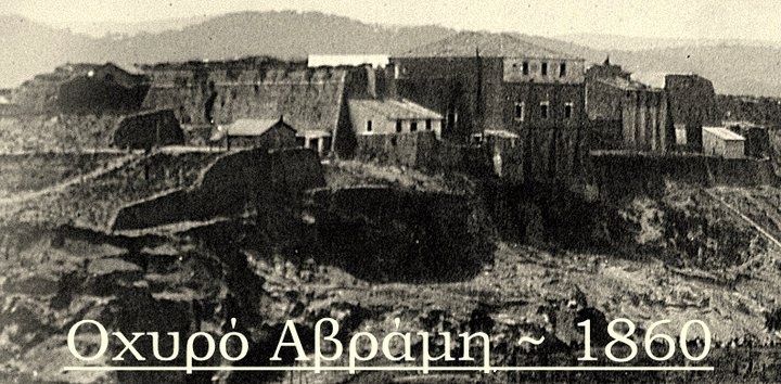
  Almost one year before I visited and photographed the negleted Avramiou Hill which stands above the hospital and behind the New Fortress. There is a rundown building on its top which used to house an elder house up to the 1980s.
  As you already may know, there was a fort on the top which was named after Avrami, a rich 16th century man who had his luxurious villa on the hill. Following the villa's destruction by the Turks in 1537, the venetian built a new peripheric fort when the turks attacked Corfu for a second time in 1716. The fort unfortunately was destroyed in 1864 by the british who left the island that year.
I thought there was hardly one image of it until today when I saw on "Corfu Old Photos" a 1860s rare dangerotype of Avrami fort before its destruction. As you can see in that documentary photo, the elder house was already there in the middle of the fortification and tall defensive walls run from its sides.


  The area now is very different. No clue of defensive walls. Only the abandoned elder house and a small building still stand, deteriorating until they collapse and become history themselves.

Sunday, 14 November 2010

Corfu Town in the late 1970s: Part Six - The environs III

  This is the sixth and the final part of this vintage tour in 70s Corfu. In this part we are going to see another ten documentary images taken from different parts of the island like Paleokastritsa, Kassiopi and Ai Gordis. All those images were scanned from a vintage tourist book of my collection.

Tourists having a tour of Paleokastritsa's caves
The little peninsula on which the Paleokastritsa'a monastery is situated
Monks chatting in Paleokastritsa's monastery
Kassiopi - Four views in one
A traditionally dressed corfiot woman

Having holidays in Acharavi
Glyfada beach and its grand hotel
French tourists in Dassia's Club Mediterranee
Swimmers in a now defunct pier of Ipsos
Ai Gordis beach before its mass tourism exploitation

Wednesday, 3 November 2010

Corfu Town in the late 1970s: Part Five - The environs II

  In this fifth part of this serie I'm going to present you ten 1970s pictures of our beloved island taken from locales like Palaiokastritsa, Benitses and Achileion.

Benitses Village
View of Benitses village from the north
Achilleion Palace
The famous gardens of Achileion fully blossomed
The view from Kanoni with the world famous Mouse Island
View of Paleokastritsa
Palaiokastritsa with its famous bays and crystal clear waters
It's summer in Paleokastritsa and tourists hit the beach 
Paleokastritsa as seen from the monastery
People at Paleokastritsa beach sunbathing

Thursday, 14 October 2010

Corfu in the past 3: The "Tennis" area as it looked in the 1860s

  The "Tennis" area is now known as a heavy populated part of Corfu Town, full of flats which named after the existing tennis court. But one hundred and fifty years earlier the place was undeveloped and then out of the town limits. Corfu in early 1860s was still under the british rule, which lasted till May 1864. Since then, the Corfu town limits were defined by the venetian walls and the areas of Mantouki, Garitsa and Sarocco were being considered as suburbs. 
  The area between the Porta Remounda and Garitsa was being called by the British as "New town" as it was the first planned residential area of Corfu Town. But it was after the british rule, in the 1870s that the area had started to build up. Ioannis Chronis (1800-1879), a corfiot architect and engineer who envisioned the area having plenty of open space and a Π - shaped form in order to be healthy for its inhabitants. Indeed, new straights road opened, among them the wide boulevard of Alexandras avenue and as soon as the land was divided in blocks, fashionable residences had started to appear scattered around the area. Even though the original plan included arcaded buildings, a church on the site of the tennis court as well as the sophisticated Π- shaped blocks, all those were scrapped in 1873 by the government in order to rise the density of the whole built-up area.

  This couple of documentary pictures below show the forementioned area before its development. In the first picture, the bay road, now known as "paraliaki tis Garitsas" already existed. In the front, we can see some marble graves scattered around a field belonged to one of the three british cemeteries in the site of the Corfu Palace hotel. In the backround, the suburb of Garitsa could be seen and further back a patch of water from Chalikiopoulos sealake (near the present airport) and above it the Agioi Deka mountain making a strong presence.


  The second one was taken from a different angle but it's prespective covers the same area. At the left, a lonesome house standed and a diagonial road (which doesn't exist nowadays) probably led to the Sarocco area. In the background, the Anemomylos area and further right the undeveloped Alexandras Avenue made a good contrast with Garitsa's buildings further back.


-Photos taken from the Alinari Archives: http://www.alinariarchives.it/internal/default.aspx

Friday, 8 October 2010

How does the interior of the Annunziata's monument looks like?

  Have you ever wondered how does the interior of a deteriorating venetian monument look like? Few days ago a user from the "Save Annunziata" group in Facebook had uploaded some photos taken in the interior of the monumental venetian campanile. I don't know how did he gained access as it is too difficult to find an entrance, and if you find one it will probably be locked.

  
As you can see in those exclusive documentary images, the interior is no way better than the exterior. Being a pigeon nest, rotten wood could be found everywhere ready to fall apart. 


Hopefully, the interior will be renovated as well and the good news are that it will be open to the public. It will be used as a viewing gallery with views towards the high streets of Eugeniou Voulgareos and Ioannou Theotoki.

Wednesday, 29 September 2010

Corfu in the past 2: "O Markás", the old market building

  In the area of the old port, existed the old market building which was bombarded by the Germans in 1943. It was a beautiful building which was one of the liveliest points in Corfu where the locals bought meat and vegetables chatting and socializing. After its demolition, being almost ruined by the bombs, the present Spilia square was built and the whole area lost its vitality and importance. 
  The postcard below was taken in the early 20th century and shows the busy market building known as "Markás" (a colloquial name probably originated from the venetian word for market "marcà"). Αt the background a portion of the New Fortress could be seen. At the foreground at the far right a young boy is resting under a tree and at the left a company is probably chatting talking loudly in the local dialect. Behind them, some market people or farmers carry the produce and a man in uniform, probably a policeman is looking at them.


  The oldest corfiots still remember the building and lament it, much like the old municipal theatre. But we should feel happy that there are some documentary photos like this which make us remember how those fine defunct buildings looked like.

Wednesday, 15 September 2010

Corfu in the past 1: Alexandras Avenue in 1973

A 37-years old photo taken from a building in Sarocco square looking towards Alexandras avenue. In this wintry show, we can see the centre of the town with fewer cars and narrower pavements/traffic islands. An old Sarakakis blue bus can be seen at the right bottom. At the left side, some cars are parked in what is now a pavement - in those days there had been a fuel station where now is "27" cafe (I still remember it still being there in the late 80s). The zebra crossings were clearly marked and some traffic lights had been adjusting the virtually non-existent traffic.


*This photo was taken from the very interesting "Corfu old Photos" group in Facebook.

Sunday, 23 May 2010

Corfu Town in the late 1970s: Part Three - The environs

The third and final part of the photos I scanned from an old guidebook. Ten photos of some beaches, villages and famous places around Corfu Town as they were in the late 1970s. The first thing we could notice by looking at those pictures is that the island still wasn't so touristically exploited as it is today. There were fewer hotels, apartments for rent and other establishments related to tourism. As a result, the island back then was greener, purer and cleaner. 
                               Ai Gordis from above - notice how undeveloped was the beach!
Ipsos, mostly untouched as well from the road to Spartylas
Kommeno bay without the villas on its hills
     Glyfada, the most popular beach of the island 
 Kassiopi, a major touristic coastal village at the northeast
Kassiopi from above
        Kouloura, right before Kassiopi, a very picturesque corner
       Paleokastritsa monastery and a two panoramic views of the location from Bella Vista
       Paleokastritsa bays are known for their scenic beauty